Urban Forest Plan
Consultation has concluded
The City of Fremantle is implementing an Urban Forest Plan, a coordinated approach to increasing the City's canopy cover from 13% to 20%.
According to the 2014 University of Technology Sydney i:tree report, the City has a 12% canopy cover. Canopy mapping undertaken by the City in 2015 and 2016 indicated we have 13% tree canopy cover.
Green spaces and trees provide a range of economic, social and environmental benefits. As the number of extreme heat days increase annually and average temperatures continue to rise, methods to cool our cities are also increasingly important for public health.
Explore your area below on the interactive map
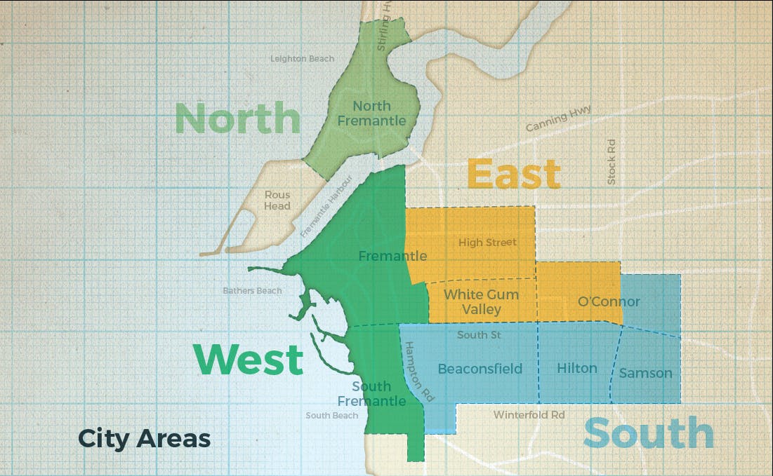
The City of Fremantle has been divided into four areas in the Urban Forest Plan. The areas were set based on topography and geology - two aspects that influence tree species form and diversity.
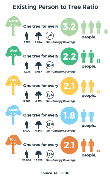
How does your area compare to the City of Fremantle average?
Native Bushland- .02%
Combined Tree Age- 55% Young, 43% Semi-Mature, 2% Post-Mature
One tree for every 2.1 people.
How hot is your block?

-
Freo's urban forest is growing
Share Freo's urban forest is growing on Facebook Share Freo's urban forest is growing on Twitter Share Freo's urban forest is growing on Linkedin Email Freo's urban forest is growing linkConsultation has concluded More than 1800 trees have been planted over the past 12 months as part of the plan to create an urban forest in Fremantle.
In the 2017-18 financial year a total of 714 trees were planted by the City of Fremantle on residential verges and in local parks, while another 92 were added as part of the landscaping component of City projects like pocket parks, car parks and walkways.
In addition, the City also planted 12,000 plants - including 1015 trees - in dunes, bushland and the river foreshore during nine community planting days and 21 volunteer planting days with conservation volunteers and local schools.
The suburb of Samson had the highest tree planting numbers in 2017/18 due to the City’s targeted Greening Samson project. A total of 212 trees were planted in Samson alone, while another 299 were planted in Beaconsfield, Hilton and Fremantle, and 203 in South Fremantle, North Fremantle, White Gum Valley and O’Connor. Read more.
-
More Trees for Samson
Share More Trees for Samson on Facebook Share More Trees for Samson on Twitter Share More Trees for Samson on Linkedin Email More Trees for Samson linkConsultation has concluded Thermal mapping carried out for the Urban Forest Plan to measure the current ‘urban heat island effect’ identified that Samson is a ‘hot spot’ with little canopy cover.
 The image to the left shows the temperature difference between the green space and surrounding urban area. The blue shading represents an important biodiversity ‘green link’ running through Samson.
This has implications for community health, so in 2018 the City of Fremantle is prioritising Samson in its annual winter planting programme, with the aim of introducing hundreds of new trees to the suburb. Most of these will be verge plantings, however there are other opportunities to introduce new trees. Find out more on the Greening Samson project page. Find out more on the Greening Samson project page.
If you are interesting in being involved in community engagement opportunities for the Samson priority planting please email communityengagement@fremantle.wa.gov.au
-
Priority Planting Areas
Share Priority Planting Areas on Facebook Share Priority Planting Areas on Twitter Share Priority Planting Areas on Linkedin Email Priority Planting Areas linkConsultation has concluded
Thermal imaging was carried out in January 2015 and has been combined with other data to develop a baseline for the four areas within the City of Fremantle.
From this priority areas will be chosen to ensure equitable distribution of green infrastructure, based on:
1. Residential areas mapped as above the baseline temperature average.
2. Infill planting to create ‘green links’; linking green spaces across the City of Fremantle.
3. Expansive hard stand areas which have the capacity to provide canopy cover and urban greening.
4. Major streetscapes or infrastructure areas with the capacity to provide canopy cover and urban greening.
5. Green spaces that need infill planting or replacement planting to maintain healthy active communities.
6. Native vegetation areas identified as Priority Conservation Action Areas that require infill planting.
7. Linking road, path and underground power works programs.
8. Annual tree planting program.
More information on the first priority areas will be released shortly.