FAQ
- Pedestrians look for consistency between signs from one point to the next on their journey. It creates comfort and certainty.
- Using the same colour, shape and format reassures the user that they are going the right way.
- Time and distance information aids journey planning and makes the decision to move between key activity nodes easier.
- Delivering the right information at the right time minimises excessive information and aids legibility.
- Good signage encourages visitors to walk around the city which brings a number of benefits.
- lacks consistency
- Doesn't give direction to pedestrians
- Doesn’t connect or link key nodes of activity
- Is badly weathered and damaged
- Does not support our current strategic marketing direction
- Lacks distinction between pedestrian and vehicle signage
- Is not regularly or consistently maintained
- Create consistent and integrated city wide way finding.
- Connect existing and future cycle, pedestrian and public transport networks.
- Create a more legible, navigable and accessible city.
- Encourage and direct flow of pedestrians between key activity nodes.
- Integrate with existing and future projects and precincts.
- Provide opportunities for learning, interpretation and integration of technology within a ‘smart’ and knowledge based economy.
Where is the system being rolled out?
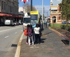
As part of the stage one rollout 31 signs were installed mainly throughout the Fremantle CBD. Stage two will involve completing signage in the CBD as well as expanding to other key activity centres in North Fremantle and South Fremantle. The system intends to create a linkage between these three key destination zones.Specific locations within these areas will be determined by a team of urban design and wayfinding experts. If you have suggestions for specific locations you can provide feedback on signage location by clicking here.
When are the signs being installed?
Stage one signs have been installed.
Stage two signs are due to be installed by the end of 2016.
Why is wayfinding signage important?
Why do we need a need a new wayfinding system?
Fremantle's existing wayfinding signage currently...
A key outcome for this project will be to disperse visitors to additional emerging destinations offering a more diverse range of experiences and spending opportunities, allowing businesses in lesser known and outlying areas such as Wray Avenue, North/South Fremantle and the West End to better leverage Fremantle’s visitor economy. This will go some way in addressing recent challenges for outlying precincts including the relocation of 1,900 workers away from Fremantle as a result of the downgrading of Fremantle Hospital. The project will also support expected growth in residents and workers as part of Fremantle’s current $1.3 billion investment pipeline, through better directing members of the community and an increased visiting workforce to local businesses and local government services such as the Library, Leisure Centre, free Wi-Fi hotspots and other important civic functions. An improved way finding system will also reduce clutter and improve the urban realm creating a more attractive environment for visitors, residents and workers, which will aid in attracting further investment to Fremantle.
What should an effective wayfinding system do?
Can I have my business name on a sign?
For reasons of equity, individual business and organisation names will not be included on the signs. Signs include directional and distance information relating to major attractions, amenities, precincts/destination zones, activity areas and transport facilities.